West Kent Local News

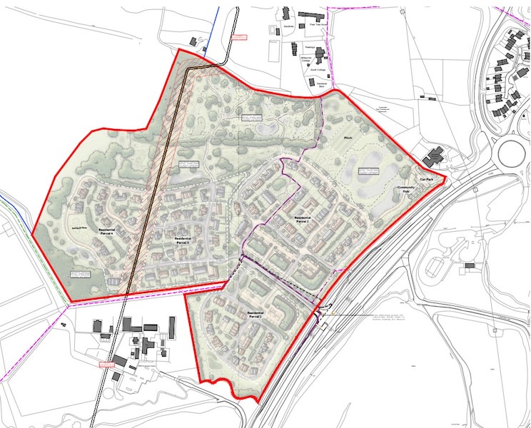
The illustrative masterplan submitted with the application, showing four residential parcels, the community hub, car park and sports pitch. Image: Hollaway Architects, drawing ref. 23,0011/101/D, via Tonbridge and Malling Borough Council's public planning register.
320 Homes Proposed for Former Oast Park Golf Course Near Snodland
Developer Obee Estates has applied to Tonbridge & Malling Borough Council to build up to 320 homes on the site of the former Oast Park Golf Course, off Malling Road near Snodland - one of the largest housing applications to land in the borough this year. Half the homes would be affordable, alongside a new community hub and sports pitch, on a site that's sat unused since the course closed nearly a decade ago.
Where it is
A golf course that never recovered
Oast Park opened as a 'pay and play' course in 1991, built by Mike Stone after he bought the 39.7-hectare site in 1990. It closed in March 2017 after Stone, its long-standing owner and operator, concluded it was no longer viable to continue - and the site has deteriorated since. A specialist Golf Needs Assessment submitted with the application puts a figure on just how far that door has closed: reopening the course would cost over £7 million, against an estimated annual profit of around £150,000 - a return of just 2.1%, far short of the 20% minimum investors typically need. Its conclusion is blunt: Oast Park is "surplus to requirements" and no longer needs protecting for golf.
What's being proposed
The application - for the 20-hectare core of the old course, with all details reserved except access - seeks permission for up to 320 homes, including 3 self-build plots, with 50% of the total as affordable housing. The existing driving range building would be demolished. The scheme, designed by Hollaway Architects, also includes a new community hub, a sports pitch, open space and landscaping. It's a significantly bigger scheme than the 100 homes the site was screened for back in 2024 - the applicant says an updated Environmental Impact Assessment has been prepared to reflect the larger proposal.
The site sits within the Metropolitan Green Belt - which covers 71% of the borough - and close to the edge of the Kent Downs National Landscape. Parts of its northern, eastern and southern boundaries fall within Flood Zones 2 and 3, two public rights of way cross the site, and a high-pressure oil pipeline requires a 12-metre easement through it. The Birling Conservation Area, with four listed buildings, lies around 720 metres to the west.
Neighbour consultation on the application closes on 5 December, with a decision due by 22 January 2027 - though no committee date has yet been set. Source: Tonbridge & Malling Borough Council, application 26/01885/OA.